The park contains the tallest sand dunes in North America, rising about 750 feet (230 m) from the floor of the San Luis Valley on the western base of the Sangre de Cristo Range, covering about 19,000 acres. They are perhaps 12,000 years old. The dunes were formed from sand and soil deposits of the Rio Grande and its tributaries, flowing through the San Luis Valley. Over the ages, westerly winds picked up sand particles from the river flood plain. As the wind lost power before crossing the Sangre de Cristo Range, the sand was deposited on the east edge of the valley. This process continues, and the dunes are slowly growing. The wind changes the shape of the dunes daily.

There are several streams flowing on the perimeter of the dunes. The streams erode the edge of the dune field, and sand is carried downstream. The water disappears into the ground, depositing sand on the surface. Winds pick up the deposits of sand, and blow them up onto the dune field once again. Digging a few inches into the dunes even at their peaks reveals wet sand. Part of the motivation of turning the Monument into a National Park was the extra protection of the water, which Colorado's cities and agriculture covet. It is very easy to experience the dune-building process. This is a very windy region, as hikers on the Sand Dunes will attest, as on many days they will be pelted by sand and even small rocks when hiking on the dunes. The wind carries sand and rocks from many miles away.

The guys running the dunes.

After a very enjoyable (and unexpected) stop here, we head on up the road a little ways to the hot springs at the Orient Land Trust.

We arrive and after a little excitement (we had squatters in our accommodations - folks who liked our cabin better than the one they had reserved), we get settled into our digs.

After the morning spent in the sand, it was literally time to wash off the trail dust (and sand).

First stop was here at the Waterfall Pool.

This is the hottest pool on the property, heated to about 105 with electricity generated from the runoff from the springs. We are completely off the electrical grid, as all electricity is generated by this runoff turning a pelsor wheel.

This pool is about 85 degrees, a good temp for the summer.

This is the sauna, which has a neat cool plunge down below.

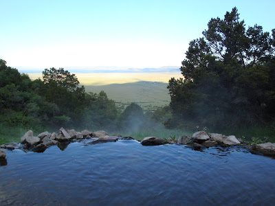
This is the view from the top springs, which requires a little hike up the mountain.

This is the large natural soaking pool.

We begin our hike up to the cave in at the old Orient Mine. The Orient Mine was an iron mine that began operation in the mid 1800’s and was abandoned by 1938. These are some of the old mine talilings

For the last thirty years or more it has been the summer home for a colony (estimated between 100,000 to 250,000) of Mexican free-tail bats - Tadarida Brasiliensis. It is the northernmost and largest bachelor colony known in North America. This colony of bats has been a very popular educational tool for two decades. This includes a master’s degree earned by a student who lived at the mine and studied the bats for two summers. On summer evenings, many visitors hike to the mine (about an hour walk over fairly steep terrain) to witness the out-flight. In 2002, work was completed to improve safety and access to the “glory hole” where the bats emerge.

Colorado was exceptionally green for this time of year. Much more rain than usual for this area, and we experienced a little rain on the hike up the mountain to see the bats and even got to see a really beautiful rain bow.

Our Bobcats on the hike up the mountain to see the bats.

One of the neat geological features on the hike, as well as a view of the San Luis Valley. We didn't get to see the bats come out, as a severe thunder storm forced us down the mountain before they made their appearance. Hate to depart, but it was time to hit the road again, taking the back roads, of course.

Our next stop will be the Black Canyon of the Gunnison National Park.

We enjoyed a nice lunch stop here.

The Black Canyon of the Gunnison's unique and spectacular landscape was formed slowly by the action of water and rock scouring down through hard Proterozoic crystalline rock.

No other canyon in North America combines the narrow opening, sheer walls, and startling depths offered by the Black Canyon of the Gunnison.

The guys on the rim.

The Black Canyon is so named on account of its steepness which makes it difficult for sunlight to penetrate very far down the canyon. As a result, the canyon walls are most often in shadow, causing the rocky walls to appear black. At its narrowest point the canyon is only 40 feet (12 m) across at the river.

The canyon has been a mighty barrier to humans. Only its rims, never the gorge, show evidence of human occupation – not even by Ute Indians living in the area since written history began.

As we leave the Black Canyon, a decision must be made: do we continue with our plans (to head across Nevada and into southern Oregon to do some camping in the Cascades) or have a mid-course change (head north to Grand Teton and Yellowstone).

Well, we decide to head north, see some neat things

and overnight in Vernal, Utah.


No comments:
Post a Comment