
Vista House was described to us by some state workers, who were there as a multi-million dollar rest room.

Clif in UnaBomber mode.

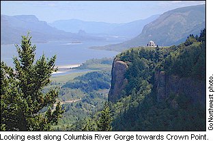
The Columbia River Gore is an 80-mile geologic wonder that forms the border between northern Oregon and southern Washington, is proof of Nature's unbridled strength. Glacial floods thousands of years ago carved this 1,200-mile-long river, which is the only sea-level passage to cross the Cascade Mountains. With cliffs rising as high as 4,000 feet, the Gorge acts as a funnel for North America's fourth largest river, whose tributaries include the mighty Snake River.
 For more than 10,000 years, the Gorge has been a resource for sustenance and survival for human generations. It has also been a source of phenomenal beauty and enjoyment, providing a playground for just about every kind of recreation. The river's canyon-like walls create ideal wind conditions for windsurfing and sailing and the majestic beauty of the area lends itself to numerous return trips. The 620-foot cascading Multnomah Falls, off of I-84, is just one of about a dozen waterfalls that are accessible from the Columbia River Highway (I-84). Other activities include river cruises, nature hikes, and kayaking.
Now, its on to the water falls:

The 249 foot high, 20 foot wide Latourell Falls cascades down a cliff on the north side of Pepper Mountain in giant steps. Water flow is significant only in the late Winter and Spring months when snow melts increase the amount of ground water.
Though you can view Latourell Falls from the highway, a short, paved, slightly downhill, path (wheelchair accessible) takes you to the base of Latourell Falls. You can also walk behind the waterfall. Another paved path (also from the parking lot) takes you to a vantage point where you can not only view Latourell Falls from above but view the 100 foot tall Upper Latourell Falls. Both of these waterfalls drop in white, horsetail forms and are very picturesque.

Looks pretty cold...

The major waterfall of Wahkeena Creek may just be the most scenic waterfall along the historic Columbia Gorge Scenic Highway. Wahkeena Creek crashes from step to step down a narrow crack between bulbous basalt outcroppings in a final furious plunge before joining the Columbia River downstream. A trail leads from a commemorative monument, honoring the completion of the original Columbia Gorge Scenic Highway, at the parking area to the base of the falls, crossing on an ornate stone bridge. Wahkeena Falls is unique among the major waterfalls in this section of the Gorge in that it possesses a significant alluvial fan in both size and elevation. The base of the falls lies a good 100 vertical feet above the road, which both helps aggrandize the falls and creates an unfortunate level of foreshortening. Lofty maple trees line the cascading creek below the falls, framing the scene in outstanding fashion. Any serious photographer should plan to spend a good hour or two here at least once in their lifetime.


Multnomah Falls Lodge, located just 30 miles east of Portland off I-84, offers breathtaking views of the second-highest year-round waterfall in the United States. With over 2 millions visitors each year, the falls and the lodge are one of Oregon’s gems. Nestled in the heart of the scenic Columbia River Gorge, the Multnomah Falls area features tree-lined hiking trails to the top of the old-world lodge that offers Northwest cuisine for breakfast, lunch and dinner.

Plummeting 620 feet from its origins on Larch Mountain, Multnomah Falls is the second highest year-round waterfall in the United States. Nearly two million visitors a year come to see this ancient waterfall.
Fed by underground springs from Larch Mountain, the flow over the falls varies, usually it's highest during winter and spring.
Multnomah Falls offers one of the best places in the Columbia River Gorge National Scenic Area to study geology exposed by floods. Five flows of Yakima basalt are visible in the fall's cliff face.


The 178 foot high, 15 foot wide Horsetail Falls plunges down a cliff on the northwest side of Larch Mountain in the shape of a giant, white horsetail. Water flows over the falls throughout the entire year.
Horsetail Falls can be viewed from the Historic Columbia River Highway but a short, half-mile trail takes you to the top of the falls and, surprise, another waterfall: Ponytail Falls (also called Upper Horsetail Falls). Another surprise - the trail takes you behind the falls!

A view of the Columbia River from the Bridge of the Gods.

The Bridge of the Gods is owned and operated by the Port of Cascade Locks. Revenues from the bridge pay for maintenance, painting, inspections, and bond repayment. The bridge tollhouse is open 24 hours a day and serves as the emergency relay station for police departments on both sides of the river. The bridge also serves as the link connecting Oregon and Washington along the tri-state Pacific Crest Trail.

After a quick tour of the trendy town of Hood River, it's on to Mount Hood and Timberline Lodge.


No comments:
Post a Comment