With the desert in my rear view, I head to the city to pick up Matthew at the Marine Recruiting Depot, San Diego.
 The Marine Corps Recruit Depot
 (commonly referred to as MCRD)
San Diego is a United States Marine Corps military installation. It lies between San Diego Bay and Interstate 5, adjacent to the San Diego International Airport and the former Naval Training Center San Diego.
MCRD San Diego's main mission is the initial training of enlisted male recruits living west of the Mississippi River. Over 21,000 recruits are trained each year. The Depot also is the home to the Marine Corps' Recruiter School and Western Recruiting Region's Drill Instructors School.

The buildings are mostly this yellow Spanish style, most dating back to the 30s. Pretty nice duty.

This is Matthew's duty station. He played the trombone in the band.

This is one of my favorites. These are the actual Quonset huts used in the filming of that classic 60s tv show: Gomer Pyle, USMC.

Life on the post seemed good. This is the barracks that Matthew called home.

Yep, barracks life seemed tough: private room and bath. Can't image why he would leave all of this! We depart the city and head out toward Death Valley.

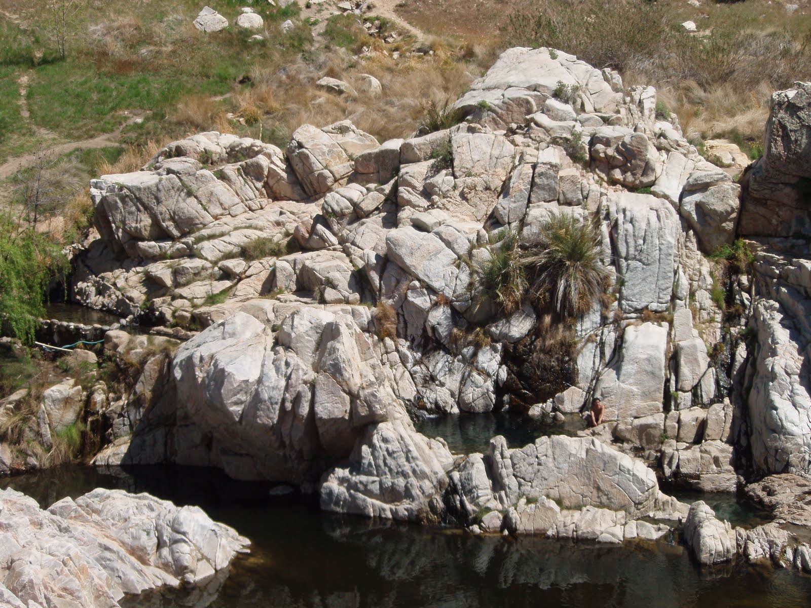
First stop was Tecopa Hot Springs to wash off the trail dust. The springs are a
public bathhouse in Tecopa, operated by California Land Management (CLM). Located in the dry desert near the southeastern boundary to Death Valley National Park. Natural hot springs emerge at 118º before being piped into the separate men and women’s bathing areas.

The men’s section has two large cement tubs, both equipped with railings and stairs leading down into the water.

Water temperatures range from 100º – 105º and the pools operate on a flow through basis so no chemicals are needed.

One of the pools is nice and hot, while the other is cooler, relatively speaking that is.

Forgot to mention, Matthew became a member of the Confederation of Reformed and Presbyterian Soakers (CoRPS). Next stop: Death Valley National Park.

Death Valley is the hottest and driest of the national parks in the United States.

The second-lowest point in the Western Hemisphere is in Badwater Basin, which is 282 feet (86 m) below sea level.

Mount Whitney, only 85 miles (137 km) to the west, rises to 14,505 feet (4,421 m). This topographic relief is the greatest elevation gradient in the contiguous United States and is the terminus point of the Great Basin's southwestern drainage. Although the extreme lack of water in the Great Basin makes this distinction of little current practical use, it does mean that in wetter times the lake that once filled Death Valley (Lake Manly) was the last stop for water flowing in the region, meaning the water there was saturated in dissolved materials. Thus the salt pans in Death Valley are among the largest in the world and are rich in minerals, such as borax and various salts and hydrates. The largest salt pan in the park extends 40 miles (64 km) from the Ashford Mill Site to the Salt Creek Hills, covering some 200 square miles (520 km2) of the valley floor.

The park is home to many species of plants and animals that have adapted to this harsh desert environment. Some examples include creosote bush, Bighorn Sheep, Coyote, and the Death Valley Pupfish, a survivor of much wetter times.

Approximately 95% of the park is designated as wilderness. Its wilderness area covers 4,774 square miles (12,360 km2), making it the largest in the Lower 48 states, and the sixth largest in the United States overall.

There are two major valleys in the park, Death Valley and Panamint Valley. Both of these valleys were formed within the last few million years and both are bounded by north–south-trending mountain ranges.

These and adjacent valleys follow the general trend of Basin and Range topography with one modification: there are parallel strike-slip faults that perpendicularly bound the central extent of Death Valley. The result of this shearing action is additional extension in the central part of Death Valley which causes a slight widening and more subsidence there.

Death Valley National Park is visited annually by more than 770,000 visitors who come to see its diverse geologic features, desert wildlife, historic sites, scenery, and clear night skies. Furnace Creek Ranch was originally built as crew headquarters for the Pacific Coast Borax Company. Now, Furnace Creek Ranch is tourist central, providing motel accommodations, eateries, t-shirts, and related tourist stuff. There is a large spring fed (warm) swimming pool here.

Mining was the primary activity in the area before it was protected. The first documented non-Native Americans to enter Death Valley did so in the winter of 1849, thinking they would save time by taking a shortcut to the gold fields of California. They were stuck for weeks and in the process gave the valley its name, even though only one of their group died there. Several short-lived boom towns sprang up during the late 19th and early 20th centuries to exploit minor local bonanzas of gold.

The only long-term profitable ore to be mined, however, was borax, a mineral used to make soap and an important industrial compound. Today, borax is an essential component of high-temperature resistant boro-silicate glass products, for example Pyrex cookware.

Twenty-mule teams were used to transport ore out of the valley; helping to make it famous and the subject of books, radio programs, television series, and movies. Now, seems like a little off roading is in order.

Chloride City is an unincorporated community in Death Valley at an elevation of 4770 feet (1454 m). A fun 4x4 road from the valley floor takes you up to Chloride City and some pretty neat views.

The settlement is a ghost town.

The town was established in 1905 when the Bullfrog, Nevada, gold discovery brought people into the area. Matthew is checking out an abandoned gold mine.

The ghost town contains numerous adits, dumps and the grave of James McKay, of whom nothing is known.

The town also holds the remains of three stamp mills.

One of the abandoned buildings in downtown Chloride.

The entrance to an old mine.

Hard to believe some of these buildings have been here for about a hundred years.

Well, its down the mountain and on to Rhyolite City, which is "one of the most photographed ghost towns in the West."

The town began in early 1905 as one of several mining camps that sprang up after a prospecting discovery in the surrounding hills. During an ensuing gold rush, thousands of gold-seekers, developers, miners, and service providers flocked to the Bullfrog Mining District. Many settled in Rhyolite, which lay in a sheltered desert basin near the region's biggest producer, the Montgomery Shoshone Mine. Industrialist Charles M. Schwab bought the Montgomery Shoshone Mine in 1906 and invested heavily in infrastructure including piped water, electric lines, and railroad transportation that served the town as well as the mine. By 1907, Rhyolite had electric lights, water mains, telephones, newspapers, a hospital, a school, an opera house, and a stock exchange. Published estimates of the town's peak population vary widely, but scholarly sources generally place it in a range between 3,500 and 5,000 in 1907–08. Rhyolite declined almost as rapidly as it rose. After the richest ore was exhausted, production fell. The 1906 San Francisco earthquake and the financial panic of 1907 made it more difficult to raise development capital. In 1908, investors in the Montgomery Shoshone Mine, concerned that it was overvalued, ordered an independent study. When the study's findings proved unfavorable, the company's stock value crashed, further restricting funding. All three banks in the town closed by March 1910. The newspapers, including the
Rhyolite Herald, the last to go, all shut down by June 1912. The post office closed in November 1913; the last train left Rhyolite Station in July 1914, and the Nevada-California Power Company turned off the electricity and removed its lines in 1916.
Within a year the town was "all but abandoned",
and the 1920 census reported a population of only 14.
A 1922 motor tour by the
Los Angeles Times found only one remaining resident, a 92-year-old man who died in 1924.
After 1920, Rhyolite and its ruins became a tourist attraction and a setting for motion pictures. Most of its buildings crumbled, were scavenged for building materials, or were moved to nearby Beatty or other towns, although the railway depot and a house made chiefly of empty bottles were repaired and preserved.

The Bank. Once most prominent was the three-story John S. Cook and Co. Bank on Golden Street.

The School.

The Bottle House, now that's a good use of old beer bottles! A miner named Tom T. Kelly built the Bottle House in February 1906 from 50,000 discarded beer and liquor bottles.

The Brothel. Hey, it's Nevada after all. Rhyolite had 50 saloons, 35 gambling tables, cribs for prostitution, 19 lodging houses, 16 restaurants, half a dozen barbers, a public bath house, and a weekly newspaper, the Rhyolite Herald. Four daily stage coaches connected Goldfield, 60 miles (97 km) to the north, and Rhyolite.

The sun setting on the mountains, as we leave Death Valley.